
CUSTOM RTK field equipment shipped to your jobsite
GeoTrek Analytics rents and provisions RTK GNSS base & rover kits, custom field reports, and utility mapping services — built for grading crews, environmental consultants, engineers, and municipal utilities across WNC. This service provides high-accuracy data collection tools on a rental basis, allowing you to get the work you need completed without massive upfront costs.
What ships in the box
Every kit arrives pre-configured to GeoTrek’s mountpoint. Power it on, connect, start collecting.
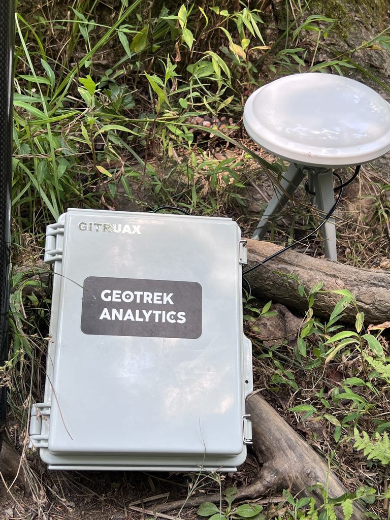
RTK Base Station
U-blox ZED-F9P board, full satellite constellation access. Ships fully configured — power on and it starts streaming corrections to your rover.
- Accuracy: 1–2 cm
- Power: Battery / Solar
- Setup time: < 10 min

Custom Rover Kit
Carbon fiber survey rod, survey-grade antenna, auto-connects to GeoTrek’s mountpoint. Works with QGIS, SW Maps, and other open-source collectors.
- Connection: Cellular / Radio
- Radio range: 10+ km
- Compacts down for easy transport

CUSTOM FIELD TOOLS
Alongside field equipment, GeoTrek Analytics creates custom field digital tools. Useful for inspections, surveys, or any other data tracking whilst in the field.
- Converts custom paper inspection forms to 1:1 digital format
- Fully offline. You own your data
- Easy exporting to CSV/Excel format
site work
Examples of field data collection, goals, results, etc.


Built around your workflow, not ours
Every industry uses the same accuracy differently. Open your trade below.
Grading & Earthwork
Common Problems: You’re eyeballing cut/fill with a laser level, or waiting on a survey crew to confirm grade. A dozer-mounted machine control receiver is a $15k+ commitment you can’t justify for every job.
How GeoTrek Fits: Rent a base + rover for the job. Walk grade checks and stakeout points yourself, same-day, at cm-level accuracy — then ship the kit back when you’re done.
Municipal / Utilities
Common Problems: Asset inventory positions (manholes, valves, hydrants) tend to be inaccurate if using handheld GPS units. Smaller assets shot with standard GPS have an average rate of error of 3-5m radius, resulting in difficulty locating/relocating assets.
How GeoTrek Fits: Capture utility assets throughout your entire system. Enter unique identifying information such as material of construction, year built, condition, and more to easily create an asset management database. Allows for return trips to the same asset with pinpoint accuracy.
Environmental Consulting
Common Problems: Wetland delineation points, stream buffers, and erosion control installs need defensible location data for regulatory submittals — consumer-grade GPS won’t hold up.
How GeoTrek Fits: Collect delineation and monitoring points at 1–2cm accuracy directly into QGIS or your preferred collector. Radio backup means rural sites without cell coverage aren’t a problem.
Engineering & Survey
Common Problems: Peak season means more topo and boundary work than your crews can cover, and public NTRIP networks are unreliable in WNC’s terrain.
How GeoTrek Fits: Add capacity without adding headcount — a shippable base/rover kit acts as a second field crew, with custom site-based corrections replacing spotty free NTRIP mountpoints.
Mailbox to jobsite
Step 1
Tell us the site
Location, terrain, and job length. We size the kit and pick cellular or radio correction based on coverage.
Step 2
It ships to you
Base and rover arrive pre-configured to your private mountpoint. No account setup, no calibration on your end.
Step 3
Power on & collect
Base streams, rover auto-connects. You’re collecting cm-accurate points in under 10 minutes.
Step 4
Ship it back
Box it up and send it back. Need data processed? We handle every format of geospatial analytics/management and deliver it to you.
1–2cm
Horizontal accuracy, validated against NC Geodetic Survey benchmark monuments
10+ km
Radio correction range for sites with no cellular coverage
<10 min
From power-on to first RTK-fixed point in the field
WNC
Based in Asheville — built for mountain terrain
renting allows flexibility, savings, and ease-of-use
Buying / Public NTRIP
- $10k–20k+ upfront for a survey-grade receiver
- Public NTRIP mountpoints drop out in WNC terrain
- Equipment sits idle between jobs
- You own the calibration and firmware problems
GeoTrek Analytics
- Job-based pricing — pay for the site, not the hardware
- Custom site-based corrections
- Shipped, configured, and supported per job
- Scale from one rover to multi-station coverage as the job needs
Tell us about your jobsite.
Most quotes go out same-day. Include the job type, rough location, and how long you’ll need the kit.
EMAIL — geotrekanalytics@gmail.com
PHONE — (828) 215-3659
SERVICE AREA — Asheville & Western NC